Tuesday, October 26, 2021
National Weather Service Report
The National Weather Service (NWS) is forecasting a Nor’easter to continue to impact Massachusetts through Wednesday afternoon. The system will bring prolonged periods of rain, flooding, damaging winds, and minor coastal flooding and beach erosion.
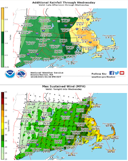
Periods of moderate to heavy rain are expected to continue across the state overnight into Wednesday morning. The axis of heaviest rainfall is expected to shift to eastern Massachusetts starting this evening. Rainfall totals through Wednesday are expected to be 2 to 4 inches with localized amounts of 3-5 inches. Rain will transition to lighter rain with occasional showers Wednesday morning then diminish to isolated showers and finally end Wednesday afternoon.
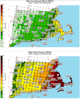
In addition to the heavy rain, minor coastal flooding is a concern for eastern MA during the Wednesday morning and late afternoon high tide cycles. The greatest risk for beach erosion is expected this afternoon into early Wednesday. Winds will increase across the state starting this evening. The strongest winds are forecasted for Tuesday night into Wednesday morning with windy conditions expected to ease Wednesday afternoon. The areas at greatest risk for wind impacts are eastern MA, Cape Cod, and the Islands. Sustained winds along the east coast are expected to range from 30- 45 mph, and 40- 55 mph on the Cape Cod and the Islands. Maximum wind gusts on the east coast are expected to range from 50- 70mph, and 60- 75 mph on Cape Cod and the Islands. The storm is expected to move offshore later Wednesday, and drier weather is expected Thursday.